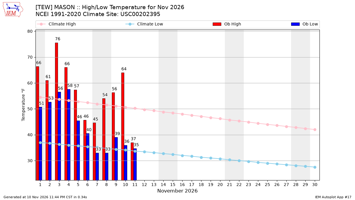
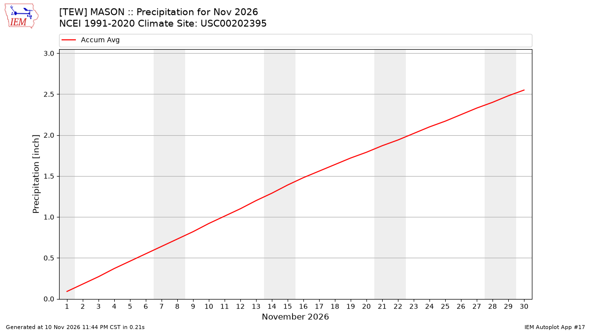
The following tables present IEM computed monthly data summaries based on
daily data provided by or computed for the IEM. A download interface
exists for the daily summary information. The climatology is provided by the
nearest NCEI climate station (USC00202395) within the current 1991-2020
dataset.
To load shown data into Microsoft Excel,
highlight the table information with your mouse and then copy/paste into Excel.
Precipitation Totals [inch]
Year
Jan
Feb
Mar
Apr
May
Jun
Jul
Aug
Sep
Oct
Nov
Dec
1997
M
0.00
0.00
0.00
0.00
0.00
0.00
0.00
0.00
0.00
0.00
0.00
1998
0.00
0.00
0.00
0.00
0.00
0.00
0.00
0.00
0.00
0.00
0.00
0.00
1999
0.00
0.00
0.00
0.00
0.00
0.00
0.00
0.00
0.00
0.00
0.00
0.00
2000
0.00
0.00
0.00
0.00
0.00
0.00
0.00
0.00
0.00
0.00
0.00
0.00
2001
0.00
0.00
0.00
0.00
0.00
0.00
0.00
0.00
0.00
0.00
0.00
0.00
2002
0.00
0.00
0.00
0.00
0.00
0.00
0.00
0.02
0.00
0.00
0.00
0.00
2003
0.00
0.00
0.00
0.00
0.00
0.00
0.00
0.00
0.00
0.00
0.00
0.00
2004
0.00
0.00
0.00
0.00
0.00
0.00
0.00
0.00
0.00
0.00
0.00
0.00
2005
0.00
0.00
0.00
0.00
0.00
0.00
0.00
0.00
0.00
0.00
0.00
0.00
2006
0.00
0.00
0.00
0.00
0.00
0.00
0.00
0.00
0.00
0.00
0.00
0.00
2007
0.00
0.00
0.00
0.00
0.00
0.00
0.00
0.00
0.00
0.00
0.00
0.00
2008
0.00
0.00
0.00
0.00
0.00
0.00
0.00
0.00
0.00
0.00
0.00
0.00
2009
0.00
0.00
0.00
0.00
0.00
0.00
0.00
0.00
0.00
0.00
0.00
0.00
2010
0.00
0.00
0.00
0.00
0.00
0.00
0.00
0.00
0.00
0.00
0.00
0.00
2011
0.00
0.00
0.00
0.00
0.00
0.00
0.00
0.00
0.00
0.00
0.00
0.00
2012
0.00
0.00
0.00
0.00
0.00
0.00
0.00
0.00
0.00
0.00
0.00
0.00
2013
0.00
0.00
0.00
0.00
0.00
0.00
0.00
0.00
0.00
M
M
M
2014
M
M
M
M
M
M
M
M
M
M
M
M
2015
M
M
M
M
M
M
M
M
M
M
M
M
2016
M
M
M
M
M
0.00
0.00
M
M
M
M
M
2017
M
M
M
M
M
M
0.00
M
M
M
M
M
2018
M
M
M
M
M
M
M
M
M
M
M
M
2019
M
M
M
M
M
M
M
M
M
M
M
M
2020
M
M
M
M
M
M
M
M
M
M
M
M
2021
M
M
M
M
M
M
M
M
M
M
M
M
2022
M
M
M
M
M
M
M
M
M
M
M
M
2023
M
M
M
M
M
M
M
M
M
M
M
M
2024
M
M
M
M
M
M
M
M
M
M
M
M
2025
M
M
M
M
M
M
M
M
M
M
M
M
2026
M
M
M
M
M
M
M
M
M
M
M
M
NCEI Climatology
2.08
1.67
1.68
3.55
4.36
3.79
3.37
3.45
3.17
3.12
2.55
1.60
Average Wind Speed [MPH]
Year
Jan
Feb
Mar
Apr
May
Jun
Jul
Aug
Sep
Oct
Nov
Dec
1997
M
7.9
8.0
7.1
8.4
5.2
4.6
4.3
5.0
5.3
6.4
6.3
1998
6.0
6.3
8.9
6.7
5.6
5.6
4.4
3.4
4.8
5.1
7.8
6.9
1999
8.9
8.0
7.9
7.3
7.1
4.8
4.9
4.3
4.8
6.3
7.2
6.7
2000
7.2
7.6
7.6
7.1
6.8
6.3
3.9
4.1
5.3
5.2
7.0
6.4
2001
6.4
8.4
7.6
8.3
5.9
4.7
4.3
4.4
4.7
7.3
6.6
6.6
2002
7.3
8.4
8.4
7.6
7.0
5.3
4.5
3.8
4.2
5.7
7.3
7.2
2003
8.0
7.4
6.7
7.5
6.4
4.4
4.4
3.6
5.3
5.4
7.4
7.6
2004
7.6
6.1
8.5
8.6
6.3
5.2
4.6
3.9
3.7
5.9
5.8
7.8
2005
6.3
5.0
6.6
7.5
5.8
4.5
3.8
3.7
4.5
4.5
8.6
6.1
2006
7.6
7.3
6.6
7.0
6.0
4.1
4.5
4.1
4.4
6.1
4.6
7.1
2007
6.0
7.9
8.4
8.7
5.6
4.1
4.3
3.8
4.4
5.5
6.9
6.7
2008
8.1
6.3
6.9
7.2
6.9
5.5
4.5
4.0
3.7
5.5
6.4
8.2
2009
5.8
7.9
7.0
8.3
6.2
4.4
4.8
4.5
3.5
5.8
5.4
6.9
2010
7.2
6.3
5.5
7.4
5.9
5.7
3.5
3.7
5.4
5.8
7.1
7.6
2011
6.4
8.6
7.8
9.1
7.2
6.7
4.0
3.8
4.9
5.8
6.9
5.9
2012
7.3
6.5
7.5
7.3
5.5
5.6
4.4
3.9
4.3
6.8
4.9
6.2
2013
7.5
7.8
7.5
8.3
6.1
4.9
3.7
3.2
4.1
4.6
8.0
6.5
2014
8.1
7.0
7.0
8.0
5.7
4.6
4.4
3.5
3.9
5.6
7.4
6.7
2015
6.7
6.3
6.5
7.0
5.6
4.7
3.9
3.9
3.9
6.7
6.7
6.8
2016
7.0
7.8
6.4
6.7
6.0
5.7
5.3
4.5
5.0
5.7
6.2
7.6
2017
6.2
7.3
8.3
7.8
6.9
6.2
4.3
4.1
3.8
5.8
6.5
6.1
2018
6.9
6.6
7.5
7.2
4.9
4.8
3.6
3.6
4.3
5.9
6.5
5.5
2019
7.6
7.4
7.1
8.4
6.6
5.8
5.0
4.7
5.4
6.6
5.8
6.8
2020
6.7
7.1
7.1
7.3
7.3
5.5
4.7
4.8
5.5
5.7
7.1
6.9
2021
5.4
6.7
8.9
7.4
6.5
5.5
5.4
4.2
5.9
5.1
5.8
6.7
2022
6.9
7.6
7.6
8.1
7.1
5.7
4.9
4.6
5.1
6.3
6.9
6.8
2023
6.0
8.4
7.0
6.8
6.2
5.7
4.6
4.8
3.7
5.5
5.6
5.7
2024
6.3
6.4
8.2
7.9
5.6
5.6
3.4
3.9
4.1
4.9
6.8
6.8
2025
7.5
7.0
8.4
7.7
6.5
4.3
3.6
3.6
2.8
4.3
6.5
7.5
2026
7.1
6.1
7.7
7.9
5.9
4.9
3.9
3.3
3.3
4.2
7.1
M
NCEI Climatology
M
M
M
M
M
M
M
M
M
M
M
M
Average Daily High Temperature [F]
Year
Jan
Feb
Mar
Apr
May
Jun
Jul
Aug
Sep
Oct
Nov
Dec
1997
M
35.60
43.50
54.98
61.03
78.26
80.43
74.45
71.06
59.58
40.21
35.25
1998
35.60
41.84
43.26
57.80
74.10
76.64
80.83
79.67
74.77
58.48
49.22
42.22
1999
29.30
39.20
42.57
59.60
72.76
79.58
84.72
76.83
76.40
60.22
53.42
37.69
2000
30.78
39.39
52.32
55.28
68.64
74.66
75.78
76.42
69.38
62.02
42.14
22.30
2001
33.97
35.73
40.59
59.66
71.83
77.36
82.17
82.69
69.98
58.71
53.42
38.39
2002
36.47
37.66
39.49
56.48
61.09
78.80
83.15
78.34
76.82
55.98
45.32
35.60
2003
26.37
30.33
48.26
57.50
64.69
75.44
80.89
81.30
71.18
58.77
49.28
36.53
2004
25.03
33.06
45.65
60.08
68.99
74.78
77.64
74.33
76.28
59.93
47.24
33.80
2005
28.52
34.40
39.78
61.58
65.27
82.16
84.49
81.47
78.08
61.38
49.88
29.00
2006
38.79
33.93
44.37
61.88
68.00
77.24
82.92
80.19
68.48
56.39
48.26
40.88
2007
32.41
24.67
48.32
54.80
72.41
80.54
82.92
82.11
76.52
67.01
46.34
33.74
2008
33.74
29.70
39.90
62.24
67.25
78.86
81.12
81.47
74.60
59.23
44.12
32.99
2009
23.70
35.66
47.97
57.86
68.99
76.22
77.12
77.52
73.22
56.15
52.28
33.10
2010
29.10
30.91
50.70
65.18
70.79
77.07
82.28
80.77
69.32
62.48
49.10
29.62
2011
25.90
31.68
40.59
53.24
66.56
76.10
85.30
77.75
67.58
59.99
50.48
37.34
2012
34.67
35.66
57.89
57.04
74.09
81.29
88.90
81.66
73.63
60.18
48.15
40.83
2013
35.05
32.45
38.69
53.80
73.38
77.07
80.86
78.82
72.73
62.15
44.19
30.76
2014
23.39
24.68
35.22
58.02
68.37
77.31
76.01
77.74
70.64
58.55
40.68
36.39
2015
26.61
20.96
41.39
57.93
70.69
73.17
77.76
75.96
76.56
60.89
53.86
45.30
2016
31.42
35.84
49.13
54.49
68.62
79.17
82.97
83.12
74.47
63.44
53.68
32.01
2017
34.16
44.44
42.21
62.14
66.56
79.25
81.24
78.75
77.96
65.32
46.36
32.13
2018
32.86
38.26
42.31
51.23
75.80
77.77
83.16
83.90
76.64
60.59
40.39
37.95
2019
27.63
31.95
41.24
56.61
67.05
75.92
84.06
80.35
75.22
60.46
40.73
39.41
2020
35.14
33.18
46.72
52.62
65.62
79.93
84.57
81.60
71.10
57.29
53.25
37.14
2021
31.70
28.23
52.84
58.91
68.41
80.44
79.92
83.07
75.47
64.72
45.62
41.37
2022
27.03
33.36
46.08
53.36
71.51
79.53
82.02
80.69
74.76
64.01
52.08
35.30
2023
35.75
39.25
43.18
59.75
72.84
81.02
83.29
78.86
72.67
60.12
48.37
43.91
2024
30.73
45.10
50.34
61.09
74.08
80.21
80.64
80.09
77.42
67.24
50.75
36.51
2025
28.28
31.65
52.56
59.52
66.45
81.22
83.84
80.50
77.43
64.85
46.82
33.91
2026
24.00
38.36
52.18
63.59
69.10
78.77
85.87
79.89
73.81
68.00
57.18
M
NCEI Climatology
31.80
34.55
44.91
57.70
70.19
79.39
83.00
81.40
75.50
61.60
48.20
37.10
Average Daily Low Temperature [F]
Year
Jan
Feb
Mar
Apr
May
Jun
Jul
Aug
Sep
Oct
Nov
Dec
1997
M
21.84
27.99
34.52
40.83
58.58
60.16
57.43
52.10
40.30
28.54
26.19
1998
27.01
29.17
30.37
38.00
52.55
57.20
59.06
60.22
55.71
44.37
34.82
26.66
1999
16.04
23.00
18.99
37.88
50.41
59.54
64.81
56.85
49.40
39.49
33.86
22.88
2000
15.05
24.61
32.17
36.44
50.93
58.28
57.37
58.42
50.00
42.97
30.14
6.45
2001
20.74
23.26
24.51
38.96
51.68
58.40
59.46
61.15
49.70
41.23
36.62
26.95
2002
23.93
22.29
22.94
38.42
41.70
57.98
61.32
58.01
51.26
37.52
31.94
20.91
2003
12.20
13.68
23.87
36.44
45.47
54.20
58.59
59.46
50.42
38.91
34.52
25.32
2004
9.88
15.99
31.77
38.06
49.19
55.58
59.46
56.15
52.82
42.05
33.20
21.72
2005
14.64
20.27
22.54
38.72
44.37
62.60
61.44
61.09
54.20
43.09
33.14
20.00
2006
28.28
18.82
26.95
39.02
48.49
56.18
62.66
59.52
50.48
37.52
34.16
29.50
2007
20.10
10.21
29.74
35.00
49.36
59.36
58.48
62.43
54.32
49.07
30.92
21.95
2008
20.27
14.99
25.26
39.38
44.60
59.36
61.09
57.14
53.36
39.49
31.52
18.06
2009
5.99
18.37
27.30
37.88
46.69
56.30
56.10
59.06
50.72
39.61
35.18
21.26
2010
16.90
20.30
28.34
40.70
51.68
60.60
62.25
60.86
51.38
40.88
30.80
18.99
2011
13.13
16.12
24.63
36.14
48.32
57.08
62.60
57.55
49.76
40.54
34.22
27.41
2012
21.43
24.30
38.85
35.48
51.73
57.19
64.63
58.31
51.39
42.93
31.00
28.37
2013
20.37
18.31
25.50
36.22
51.18
58.42
61.43
58.22
50.68
42.91
30.43
19.74
2014
6.17
7.67
17.03
35.64
47.46
58.82
55.70
58.18
48.70
39.85
26.91
26.15
2015
12.67
0.15
22.59
35.81
50.27
54.87
57.03
57.53
55.86
43.92
35.54
33.31
2016
19.52
21.08
31.11
34.86
47.76
56.54
61.32
62.38
55.98
44.95
36.68
22.37
2017
24.21
27.32
27.23
42.82
47.41
58.44
60.35
56.72
53.19
47.47
31.88
18.01
2018
17.49
22.65
26.72
32.06
55.31
59.71
60.41
63.72
57.31
43.52
30.94
27.04
2019
18.85
24.05
25.95
38.87
47.59
57.91
65.31
58.76
56.91
42.54
27.55
26.07
2020
24.98
19.47
30.79
34.43
47.76
56.82
64.19
59.18
50.77
38.71
35.22
25.24
2021
21.41
9.91
30.32
37.81
45.04
60.11
61.66
61.91
53.37
49.69
29.82
28.15
2022
10.02
16.39
28.07
36.61
51.78
57.81
60.91
60.39
55.47
42.17
34.77
25.23
2023
27.01
24.24
28.20
38.76
47.28
57.05
62.94
59.16
54.07
45.00
29.46
34.45
2024
22.84
27.52
32.44
41.72
52.61
60.64
61.18
61.07
53.46
42.90
38.21
26.56
2025
15.73
18.47
32.03
37.54
47.15
60.17
64.42
58.20
51.58
42.44
31.06
18.72
2026
10.00
20.70
30.78
43.19
47.04
58.26
61.92
61.51
54.57
44.41
43.32
M
NCEI Climatology
17.51
18.91
27.20
37.30
48.40
57.59
61.20
59.80
51.80
41.50
32.21
23.50
Average Daily Temperature (high+low)/2 [F]
Year
Jan
Feb
Mar
Apr
May
Jun
Jul
Aug
Sep
Oct
Nov
Dec
1997
M
28.72
35.75
44.75
50.93
68.42
70.29
65.94
61.58
49.94
34.38
30.72
1998
31.30
35.50
36.82
47.90
63.33
66.92
69.95
69.95
65.24
51.42
42.02
34.44
1999
22.67
31.10
30.78
48.74
61.58
69.56
74.76
66.84
62.90
49.85
43.64
30.29
2000
22.91
32.00
42.25
45.86
59.78
66.47
66.58
67.42
59.69
52.50
36.14
14.38
2001
27.35
29.49
32.55
49.31
61.76
67.88
70.82
71.92
59.84
49.97
45.02
32.67
2002
30.20
29.97
31.22
47.45
51.39
68.39
72.24
68.17
64.04
46.75
38.63
28.25
2003
19.28
22.00
36.06
46.97
55.08
64.82
69.74
70.38
60.80
48.84
41.90
30.93
2004
17.45
24.52
38.71
49.07
59.09
65.18
68.55
65.24
64.55
50.99
40.22
27.76
2005
21.58
27.33
31.16
50.15
54.82
72.38
72.96
71.28
66.14
52.24
41.51
24.50
2006
33.54
26.37
35.66
50.45
58.25
66.71
72.79
69.86
59.48
46.95
41.21
35.19
2007
26.25
17.44
39.03
44.90
60.89
69.95
70.70
72.27
65.42
58.04
38.63
27.85
2008
27.01
22.35
32.58
50.81
55.92
69.11
71.11
69.31
63.98
49.36
37.82
25.53
2009
14.84
27.02
37.63
47.87
57.84
66.26
66.61
68.29
61.97
47.88
43.73
27.18
2010
23.00
25.60
39.52
52.94
61.24
68.83
72.27
70.82
60.35
51.68
39.95
24.31
2011
19.52
23.90
32.61
44.69
57.44
66.59
73.95
67.65
58.67
50.26
42.35
32.38
2012
28.05
29.98
48.37
46.26
62.91
69.24
76.76
69.99
62.51
51.55
39.58
34.60
2013
27.71
25.38
32.10
45.01
62.28
67.75
71.14
68.52
61.70
52.53
37.31
25.25
2014
14.78
16.18
26.13
46.83
57.91
68.07
65.85
67.96
59.67
49.20
33.79
31.27
2015
19.64
10.55
31.99
46.87
60.48
64.02
67.39
66.74
66.21
52.40
44.70
39.30
2016
25.47
28.46
40.12
44.68
58.19
67.85
72.15
72.75
65.22
54.19
45.18
27.19
2017
29.19
35.88
34.72
52.48
56.99
68.85
70.80
67.74
65.58
56.40
39.12
25.07
2018
25.18
30.46
34.51
41.65
65.55
68.74
71.78
73.81
66.97
52.06
35.66
32.50
2019
23.24
28.00
33.59
47.74
57.32
66.92
74.69
69.55
66.07
51.50
34.14
32.74
2020
30.06
26.32
38.76
43.53
56.69
68.38
74.38
70.39
60.93
48.00
44.23
31.19
2021
26.56
19.07
41.58
48.36
56.72
70.28
70.79
72.49
64.42
57.20
37.72
34.76
2022
18.52
24.87
37.07
44.98
61.64
68.67
71.46
70.54
65.11
53.09
43.43
30.27
2023
31.38
31.74
35.69
49.25
60.06
69.03
73.11
69.01
63.37
52.56
38.91
39.18
2024
26.79
36.31
41.39
51.41
63.34
70.43
70.91
70.58
65.44
55.07
44.48
31.54
2025
22.01
25.06
42.29
48.53
56.80
70.70
74.13
69.35
64.50
53.64
38.94
26.31
2026
17.00
29.53
41.48
53.39
58.07
68.52
73.90
70.70
64.19
56.21
50.25
M
NCEI Climatology
24.65
26.73
36.05
47.50
59.30
68.49
72.10
70.60
63.65
51.55
40.20
30.30
Average Relative Humidity [%]
This value is computed via a simple average of available observations weighted
by the duration between observations.