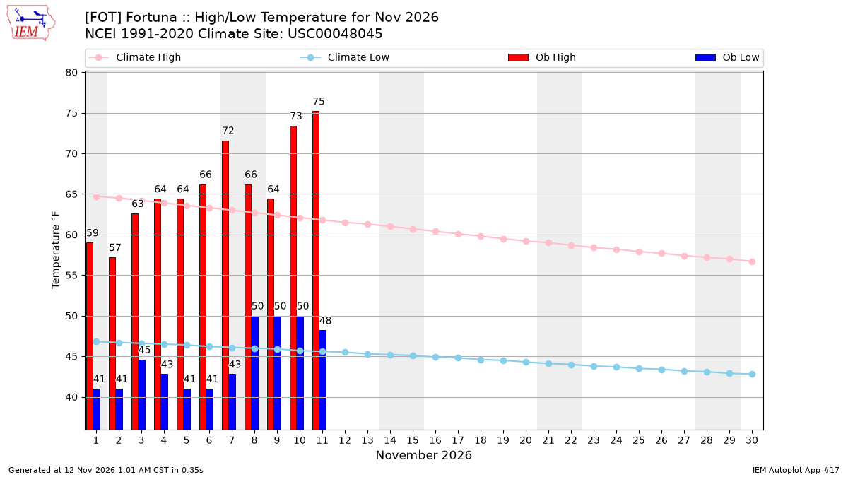
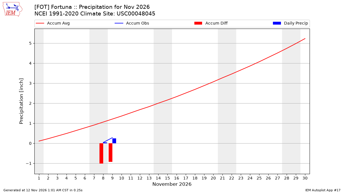
The following tables present IEM computed monthly data summaries based on
daily data provided by or computed for the IEM. A download interface
exists for the daily summary information. The climatology is provided by the
nearest NCEI climate station (USC00048045) within the current 1991-2020
dataset.
To load shown data into Microsoft Excel,
highlight the table information with your mouse and then copy/paste into Excel.
Precipitation Totals [inch]
Year
Jan
Feb
Mar
Apr
May
Jun
Jul
Aug
Sep
Oct
Nov
Dec
2011
M
M
M
M
M
M
M
M
0.19
1.99
4.58
1.31
2012
5.63
2.39
9.45
3.59
0.46
1.42
1.26
0.01
0.01
2.03
5.43
7.90
2013
1.68
1.12
2.32
0.98
0.67
0.20
0.00
0.03
2.11
0.03
1.03
0.13
2014
M
0.63
4.23
1.14
0.62
0.06
0.02
M
1.86
3.89
2.90
9.22
2015
0.87
7.15
1.73
2.68
0.18
M
0.20
0.26
0.56
0.53
3.82
10.14
2016
10.68
1.16
5.81
2.19
0.88
0.12
0.05
0.04
0.03
5.53
3.75
4.12
2017
8.92
9.05
4.51
4.24
0.66
0.18
0.00
0.09
0.46
0.78
3.04
0.82
2018
3.25
2.12
5.87
2.93
0.47
0.33
M
M
0.26
0.20
M
M
2019
3.52
11.45
4.07
1.36
2.19
M
0.05
M
0.92
1.27
1.62
5.68
2020
2.22
0.27
1.52
1.15
2.18
0.20
M
M
0.12
0.04
1.47
1.68
2021
3.27
1.10
1.62
0.26
0.01
0.09
0.03
M
0.28
1.80
0.79
4.67
2022
0.58
0.21
1.40
3.06
1.27
0.30
0.07
M
M
0.07
2.29
6.85
2023
7.83
3.60
4.73
M
0.01
0.07
0.01
M
1.12
0.95
2.11
4.57
2024
8.23
5.83
5.71
1.07
1.55
0.25
0.01
1.00
0.05
0.77
8.19
6.50
2025
1.15
5.90
5.50
0.87
0.41
M
0.01
M
0.36
0.68
4.34
7.90
2026
2.34
3.60
0.17
1.55
0.28
0.16
M
0.02
0.17
0.20
0.28
M
NCEI Climatology
8.59
8.11
6.93
3.89
1.91
0.57
0.14
0.05
0.47
2.38
5.23
9.68
Average Wind Speed [MPH]
Year
Jan
Feb
Mar
Apr
May
Jun
Jul
Aug
Sep
Oct
Nov
Dec
2011
M
M
M
M
M
M
M
M
7.5
6.4
6.3
5.8
2012
8.4
8.0
10.3
6.3
8.2
8.6
6.6
4.9
4.6
4.3
9.0
8.8
2013
5.9
5.9
6.4
7.0
7.2
3.5
0.5
7.0
7.5
7.0
7.3
7.2
2014
M
10.7
9.0
7.5
8.4
8.6
7.1
7.1
7.1
8.0
8.0
10.6
2015
7.0
8.7
6.8
8.1
7.9
7.2
7.2
6.6
6.8
6.3
7.4
10.0
2016
12.1
7.2
9.7
8.4
7.4
7.7
7.5
6.5
6.6
9.2
9.0
7.6
2017
9.4
9.7
8.2
9.8
8.4
7.7
7.1
6.0
7.0
7.6
9.1
6.8
2018
9.0
7.5
8.7
8.0
7.8
9.0
7.0
6.1
7.2
6.4
7.6
8.6
2019
9.7
8.9
7.6
8.4
8.2
8.5
8.5
7.5
7.2
8.1
7.4
9.3
2020
6.8
5.8
6.7
6.6
8.0
8.1
7.8
6.9
6.4
6.9
8.2
7.8
2021
10.1
7.7
8.8
7.7
9.3
8.2
6.7
6.9
6.0
7.8
6.5
7.7
2022
7.2
7.8
7.9
9.1
8.6
4.7
1.7
6.6
5.2
5.9
7.4
9.7
2023
11.1
6.7
7.1
M
7.2
6.6
6.7
6.0
6.0
5.8
4.9
6.4
2024
8.6
6.7
7.0
6.7
7.9
7.4
6.1
5.6
5.5
6.2
8.3
6.7
2025
6.3
8.5
8.9
9.9
9.2
8.2
6.8
6.7
6.3
6.8
8.0
7.2
2026
7.6
8.3
3.4
6.1
6.6
7.7
7.0
6.7
6.6
6.1
6.6
M
NCEI Climatology
M
M
M
M
M
M
M
M
M
M
M
M
Average Daily High Temperature [F]
Year
Jan
Feb
Mar
Apr
May
Jun
Jul
Aug
Sep
Oct
Nov
Dec
2011
M
M
M
M
M
M
M
M
71.06
63.76
55.88
53.25
2012
54.59
54.97
53.31
57.50
58.30
61.76
61.76
64.63
62.91
64.63
59.72
50.99
2013
52.09
52.64
54.70
57.38
61.73
65.36
63.47
68.84
69.56
62.02
59.96
51.35
2014
M
56.00
58.94
59.72
63.35
64.34
66.55
67.45
69.14
68.12
61.53
56.68
2015
59.00
59.77
59.00
57.74
58.36
64.34
69.45
70.03
67.16
67.94
57.68
53.14
2016
56.10
60.49
57.90
61.70
61.61
64.64
64.98
65.79
66.39
62.83
61.10
51.39
2017
51.22
54.05
56.39
58.34
59.17
63.32
64.75
67.77
71.96
63.76
58.70
51.92
2018
55.81
53.47
55.46
57.74
58.94
63.38
66.37
65.91
67.16
64.11
61.28
54.82
2019
56.91
48.65
51.74
56.30
58.48
64.28
67.13
71.72
68.84
64.46
58.28
55.28
2020
53.40
52.86
53.43
58.40
61.61
64.04
64.66
66.20
71.90
65.56
58.48
55.51
2021
53.95
51.67
52.31
56.24
57.56
65.42
62.31
66.32
66.56
62.33
59.12
49.36
2022
55.21
55.34
56.50
54.80
58.54
64.88
64.91
67.59
64.20
62.60
54.62
52.55
2023
52.79
50.51
49.47
M
59.08
60.26
64.92
69.05
66.86
64.28
60.92
56.85
2024
55.75
53.79
53.77
56.18
60.16
62.54
67.07
68.06
67.58
66.95
56.72
56.62
2025
54.94
52.38
55.40
55.98
59.12
62.06
63.88
67.40
66.63
64.17
59.60
56.45
2026
56.54
56.69
56.52
58.04
59.70
63.68
66.43
66.49
66.74
62.83
66.35
M
NCEI Climatology
56.59
57.82
59.20
61.60
64.40
67.19
70.00
71.60
72.50
68.60
60.60
55.10
Average Daily Low Temperature [F]
Year
Jan
Feb
Mar
Apr
May
Jun
Jul
Aug
Sep
Oct
Nov
Dec
2011
M
M
M
M
M
M
M
M
52.88
49.42
42.08
36.76
2012
39.32
40.63
39.43
44.54
45.70
48.92
52.58
51.45
47.89
48.55
46.58
39.20
2013
37.52
38.43
41.93
44.36
47.04
50.60
50.29
53.54
52.82
44.08
42.26
36.95
2014
M
47.00
44.14
44.30
49.30
49.16
52.90
53.99
52.10
51.68
47.60
46.52
2015
44.02
44.60
45.35
42.68
47.21
49.94
53.89
54.35
50.18
50.81
40.58
41.70
2016
44.37
43.54
43.90
46.70
48.55
50.12
51.80
50.00
50.00
49.94
46.34
36.18
2017
36.99
42.41
43.96
43.70
47.39
50.36
50.99
52.50
52.82
45.70
45.74
34.03
2018
43.44
36.76
40.19
42.98
47.79
48.62
50.75
52.96
48.50
46.69
43.34
40.59
2019
41.75
36.24
37.75
45.02
47.15
47.83
54.18
54.47
53.60
43.70
41.72
43.26
2020
41.70
38.58
39.32
44.06
47.33
49.28
50.06
51.80
53.42
47.21
42.20
39.65
2021
41.06
40.74
38.04
41.66
45.38
50.18
50.64
50.75
48.68
47.53
44.66
39.49
2022
39.84
38.81
40.94
39.92
44.72
49.16
53.34
53.19
52.40
45.07
38.36
39.37
2023
38.85
35.73
36.07
M
48.13
48.32
51.80
53.72
51.14
47.33
43.04
44.02
2024
44.83
41.74
40.77
42.62
44.60
47.96
51.39
51.51
49.70
46.40
41.96
42.51
2025
38.27
38.75
41.81
44.41
46.52
47.78
50.87
52.52
54.10
47.15
45.98
42.45
2026
40.04
42.80
44.15
43.58
47.27
48.98
52.43
52.50
50.42
44.95
45.05
M
NCEI Climatology
42.60
42.70
43.50
45.20
48.60
51.40
53.50
54.20
51.90
48.30
44.91
41.60
Average Daily Temperature (high+low)/2 [F]
Year
Jan
Feb
Mar
Apr
May
Jun
Jul
Aug
Sep
Oct
Nov
Dec
2011
M
M
M
M
M
M
M
M
61.97
56.59
48.98
45.01
2012
46.95
47.80
46.37
51.02
52.00
55.34
57.17
58.04
55.40
56.59
53.15
45.09
2013
44.80
45.53
48.32
50.87
54.38
57.98
56.88
61.19
61.19
53.05
51.11
44.15
2014
M
51.50
51.54
52.01
56.33
56.75
59.73
60.72
60.62
59.90
54.57
51.60
2015
51.51
52.19
52.18
50.21
52.79
57.14
61.67
62.19
58.67
59.38
49.13
47.42
2016
50.23
52.02
50.90
54.20
55.08
57.38
58.39
57.90
58.19
56.39
53.72
43.79
2017
44.11
48.23
50.17
51.02
53.28
56.84
57.87
60.13
62.39
54.73
52.22
42.97
2018
49.62
45.11
47.82
50.36
53.37
56.00
58.56
59.44
57.83
55.40
52.31
47.71
2019
49.33
42.45
44.75
50.66
52.82
56.05
60.65
63.09
61.22
54.08
50.00
49.27
2020
47.55
45.72
46.37
51.23
54.47
56.66
57.36
59.00
62.66
56.39
50.34
47.58
2021
47.50
46.21
45.18
48.95
51.47
57.80
56.47
58.54
57.62
54.93
51.89
44.43
2022
47.53
47.08
48.72
47.36
51.63
57.02
59.13
60.39
58.30
53.83
46.49
45.96
2023
45.82
43.12
42.77
M
53.60
54.29
58.36
61.38
59.00
55.81
51.98
50.44
2024
50.29
47.77
47.27
49.40
52.38
55.25
59.23
59.78
58.64
56.68
49.34
49.56
2025
46.60
45.56
48.61
50.19
52.82
54.92
57.37
59.96
60.37
55.66
52.79
49.45
2026
48.29
49.74
50.34
50.81
53.48
56.33
59.43
59.49
58.58
53.89
55.70
M
NCEI Climatology
49.60
50.26
51.35
53.40
56.50
59.30
61.75
62.90
62.20
58.45
52.75
48.35
Average Relative Humidity [%]
This value is computed via a simple average of available observations weighted
by the duration between observations.